You’ve heard of cloud nine – but what about clouds one through 10? Looking to the heavens, weather presenter and meteorologist Nate Byrne handcuffs thunder, throws lightning in jail, and even comes up with an entirely new word for “fog”.
This article connects Chemical, Earth and Space, and Physical sciences for students in all years by looking at the formation and classification of clouds. It could be used to highlight a different STEM career opportunity as well as an alternative application of particle models and gas laws.
Word Count: approx. 2200
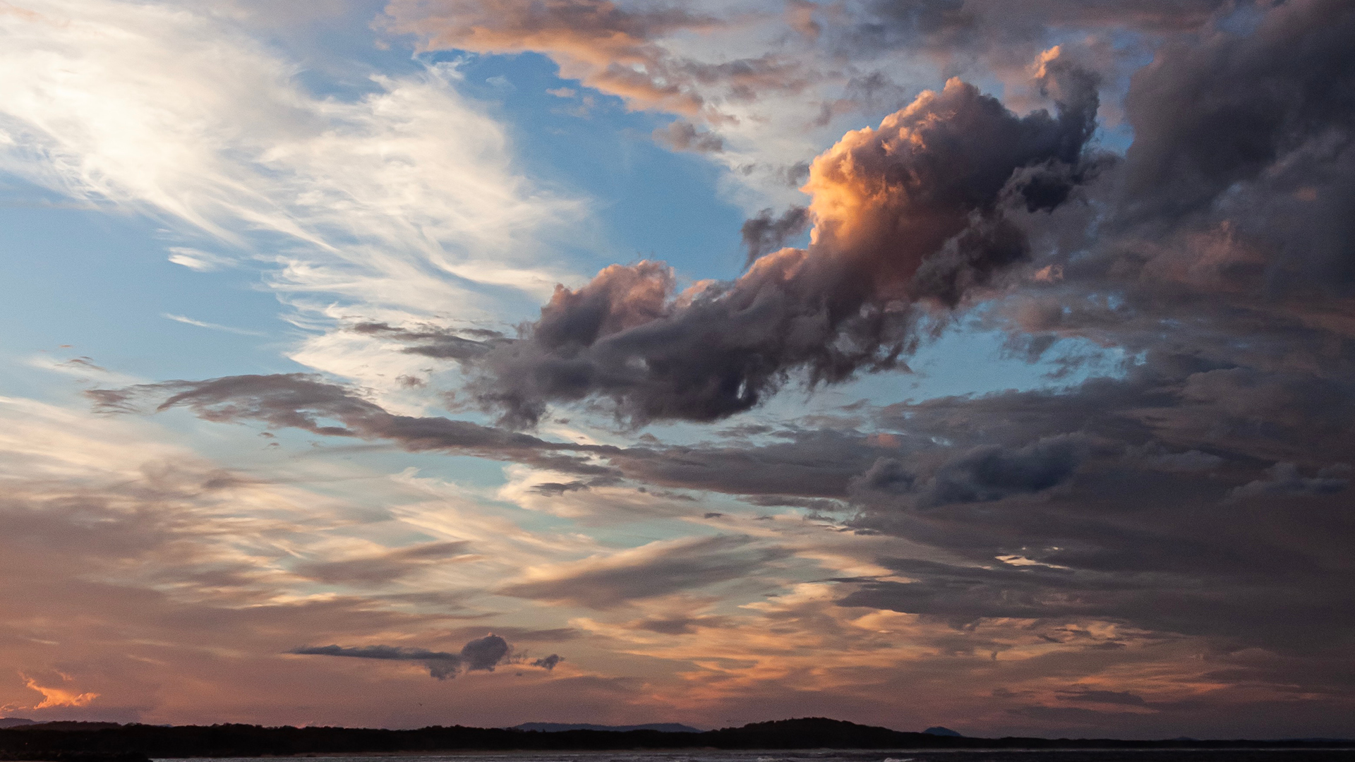
When you look up at the sky and spot an interesting cloud, you may see a bunny, a hippo or a cake chasing a lollypop. When meteorologists see a cloud, it’s hard for them to do anything other than try to figure out how to classify it.
We all appreciate the importance of classification when it comes to animals – it helps us figure out relationships, relatedness and where creatures fit in the complex ecological web. Classification provides a similar function for clouds, but it can also tell us about what we might expect on the ground – either from that specific cloud, or from a synoptic system that helped to generate it.
Echoing the techniques used by our biologist cousins, meteorologists have organised clouds into genera, species and varieties. Unlike the animal kingdom, though, clouds can move between types, they can grow extra features or lose them, and two different people looking at the exact same cloud from different vantage points can have wildly different ideas about what they are seeing.
Everyone has their favourite, and you may already know its name – cumulonimbus or cirrus – but knowing why it’s called that can tell you a bit about what caused it, and what it might go on to do. There are a few basic guidelines and several methods of attack when trying to tie your cloud down.
What cloud is that?
Clouds are the weather we can see, and they can tell us a lot about what’s happening in the atmosphere. Where clouds form, air is (almost always) moving upwards. That’s something air doesn’t generally like to do – sideways is relatively easy, but up and down are much more difficult, because you’re either fighting gravity or trying to push towards an area of higher pressure. When you do get the air to move upwards, though, you bump into the good old combined gas law: P1V1/T1 = P2V2/T2.
Higher in the atmosphere the pressure is lower, so any air that pushes up there expands and the temperature drops. Air holds water vapour, and when you drop the pressure or the temperature, the saturation point also drops. When it’s high enough (or cool enough), the air reaches 100% humidity and excess water vapour condenses into water droplets. That’s the start of a cloud.
There are two ways you can get air to move upwards – either give it a sharp kick from an external force, or gently sweep it. This informs what kind of cloud you end up with, and that’s how I like to start my classification, with the age-old question: Is it lumpy or layered?
Lumpy: When air gets pushed upwards explosively – perhaps by heating it or by forcing it up a mountain range like a skateboarder on a ramp going for some epic air – eddies and currents around the airmass cause the cloud particles to take on structure. It can look lumpy or fluffy like a scoop of ice-cream or cotton wool. It’s all kind of piled up, hence their name: cumuliform.
Layered: If your cloud is created gently by cooling it down to saturation, or by slowly pushing it up in the atmosphere, it takes on a much more uniform appearance. Those days when clouds look flat and stripy – that’s when you’re dealing with stratiform clouds.
Lumpy and Layered: Sometimes it’s really hard to tell exactly what’s going on – you’ve got something that looks like a layered cloud, but there are some features, or maybe your cumuliform clouds are spreading out and joining; that’s when to just mix the two and call it stratocumulus.
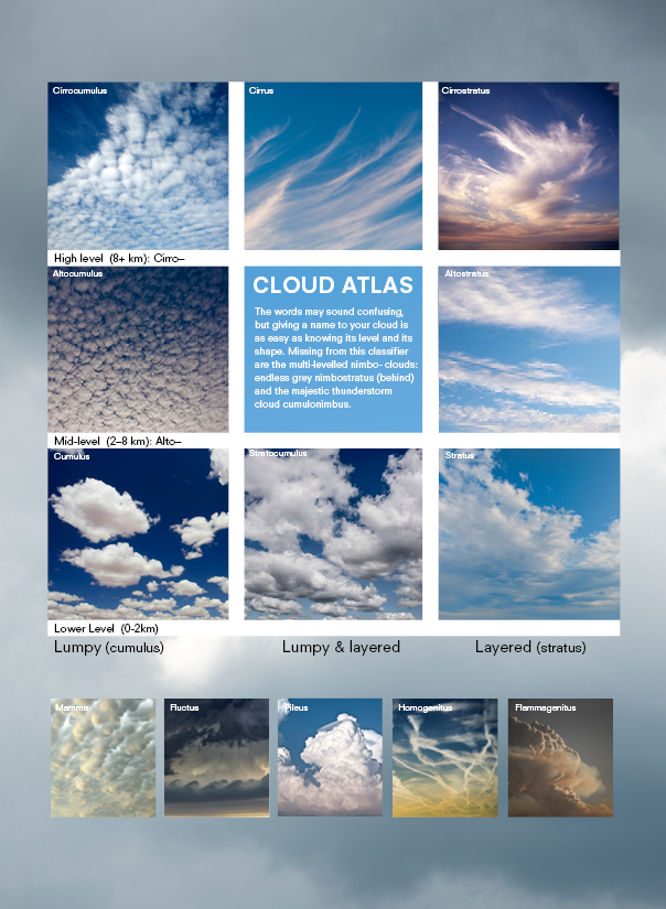
Next, think about how high your cloud is. This can be tricky, because the depth of the troposphere (the lower levels of the atmosphere where almost all of the weather happens) changes depending on where you are on the planet. At the poles the atmosphere is significantly smaller than at the equator, largely because warm air takes up more space.
Clouds in the lower regions – from the surface to about two kilometres – are generally made of liquid water, and get the straight names: cumulus and stratus.
Mid-level clouds are a mix of liquid water (often supercooled below 0°C) and ice crystals. These get the prefix “alto” – so altostratus and altocumulus.
In the high levels, it’s all ice, which makes for a much more wispy appearance. To our meteorological forebears these clouds looked like mares’ tails, which may explain their Latin hair-curl-inspired name “cirrus”. They are often difficult to clearly define, so cirrus is a cloud in its own right, along with cirrostratus and cirrocumulus.
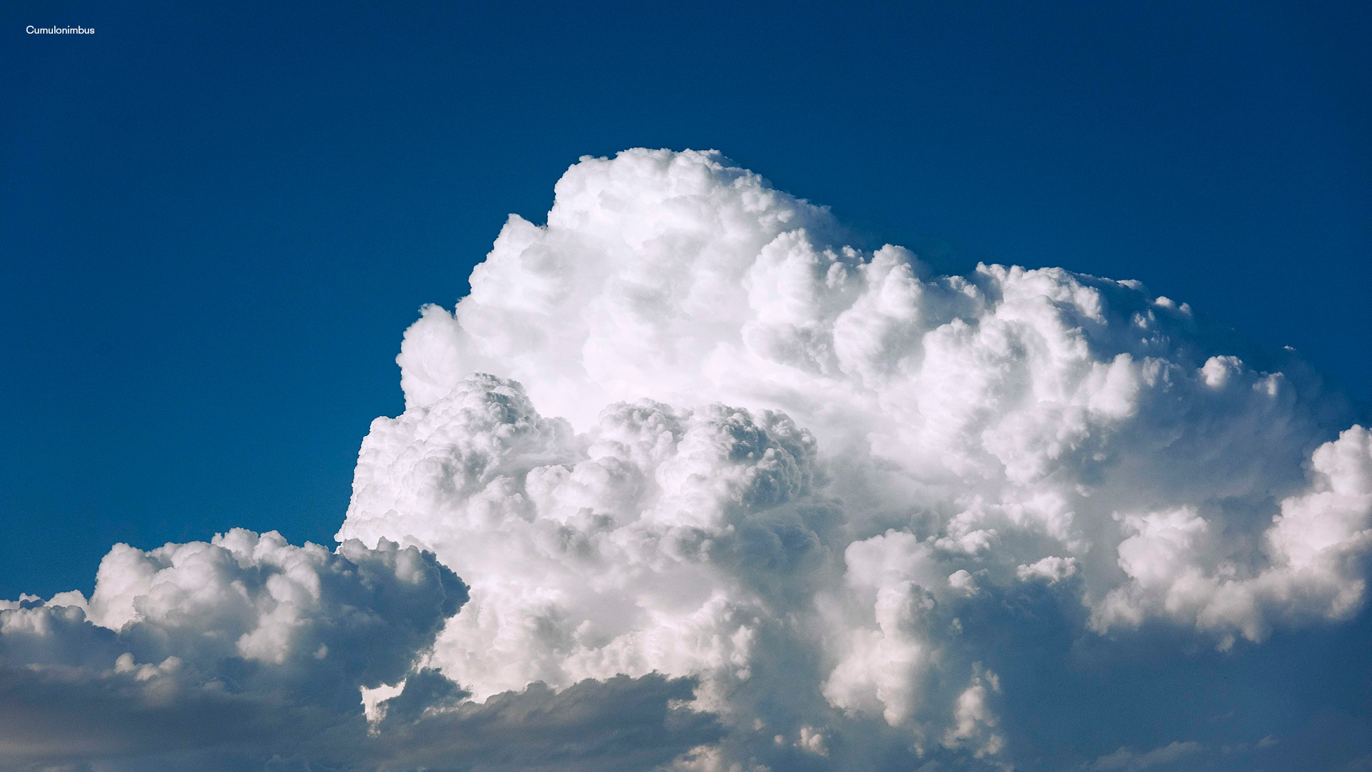
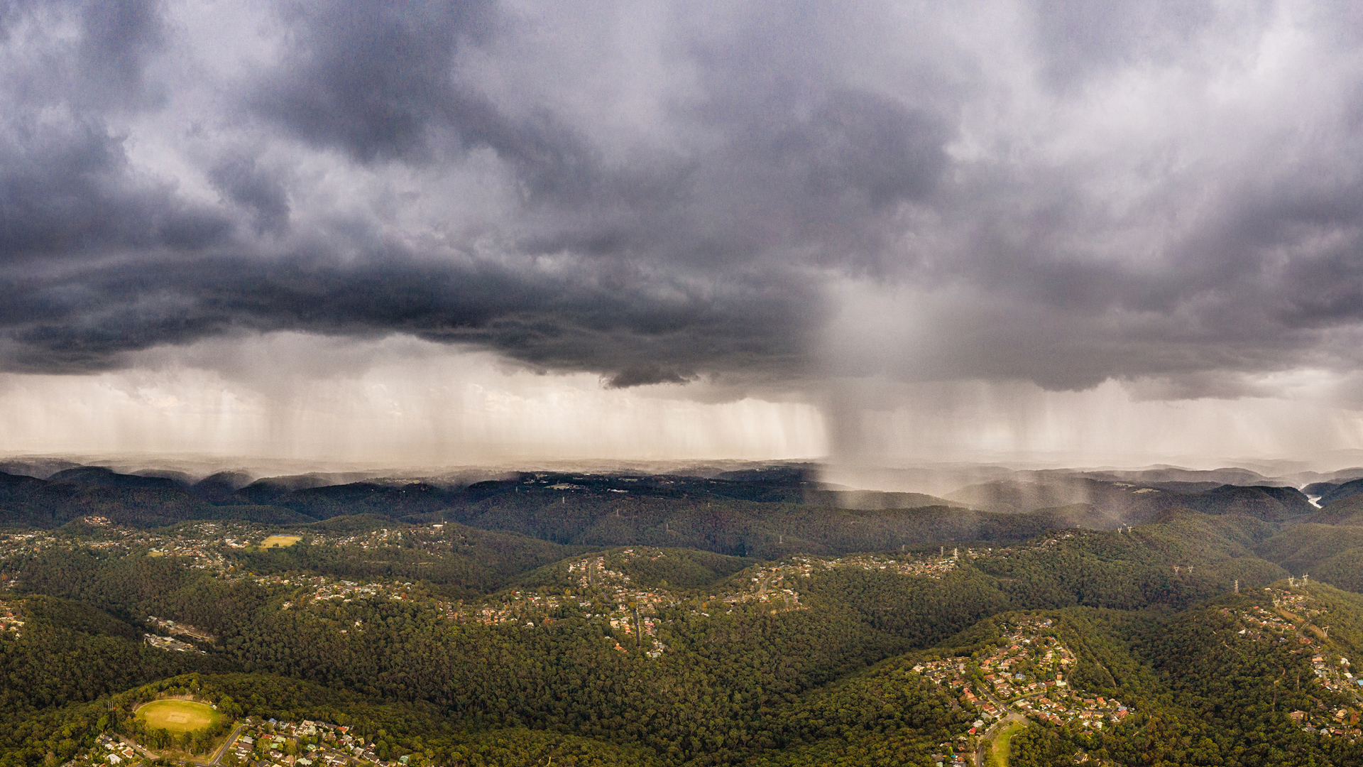
Sometimes clouds extend through several layers – “nimbus”. Nimbostratus is a wall of featureless cloud that heralds a very wet day, while cumulonimbus (below) is the cloud most people tell me they love – a thunderstorm.
Put all that together and we’ve got the 10 genera that all clouds fit into. But there’s a whole range of other features that can give the species in the classification. Is it towering, are there waves or lobes? If you want to explore the cornucopia, the World Meteorological Organisation’s International Cloud Atlas is your one-stop-shop.
Now that you can name your nearest cloud, I hope you’re wondering: What can it actually do?
Rain Dances
When it comes to rain, size matters. While a fairly small cloud can hold large amounts of water, a good, average-sized small cumulus can easily yield a volume in the cubic kilometre range. The liquid water density of a fair-weather cumulus (a fluffy white cottonball that won’t rain) is around 0.5 grams per cubic metre (g/m3), and that represents roughly 500 tonnes of water in the air. In a cumulonimbus, the density can be as much as six times that, with the cells reaching potentially 20 kilometres into the atmosphere with a footprint many kilometres across. The amount of water these clouds hold can be incredible – one of 20km3 could hold 9600 Olympic swimming pools of water.
Tiny cloud droplets have a fair distribution, measuring anywhere from one to 100 microns in size, and are easily kept aloft like motes of dust. In fact, every raindrop starts as a mote of dust, or a grain of salt, a particle of pollution, a bacterium, a fungal spore or some other similarly sized particle in the atmosphere. Water doesn’t like to condense out of clean air; it prefers a surface of some sort, which is why you can have misty windows in a clear car.
The droplets bump into each other on air currents, combining as they collide. Like a steamy bathroom mirror, they remain suspended until they get large enough that gravity forces them downwards, 100 to 1000 times larger than when they formed.
Once a drop leaves the cloud, it finds itself surrounded by air with relative humidity less than 100%, so it starts to evaporate. If you’ve ever noticed a raincloud with a shaggy underside, you’re seeing a cloud that has formed as the rain raises the humidity of the air below its parent cloud. If the rain evaporates before it hits the ground, it leaves visible streaks that slowly vanish called “virga”.
Cumulus clouds tend to cause showers – on-again-off-again rain that reflects the cellular nature of the clouds, but with heavy raindrops because of the strength of the updrafts that create them. Stratus clouds’ individual drops are usually smaller, since there aren’t turbulent winds to make them collide, but they usually cause steady falls that last a long time, which can result in large totals on the ground.
Inside a cumulonimbus cell, huge updrafts keep the drops in the air for a long time, allowing them to grow very large, often taking them above freezing altitude to create hail. (This is a different process to the formation of snow, which is usually driven by water vapour attaching to pre-existing ice crystals, growing until they are too heavy to be kept aloft.)
When these large raindrops finally fall and start to evaporate, they cool the air around them – much like sweat cools you when a breeze is applied – and this can have dangerous implications. If the air is cooled sufficiently it can become much less buoyant than its surroundings and crash rapidly to earth, causing microbursts with erratic winds blowing hundreds of kilometres an hour.
Cloud. on. ground.
On a foggy morning, when you step out the front door, you are walking into a cloud. Fog is just cloud on the ground (which makes me want to rename it “cog” – if there’s a petition, let me know). To create “cog”, the ingredients need to be just right.
First of all, you want the air to have some moisture – the more the better, because it will take less effort to get it to saturation. Next, you want the air to cool down. A clear, cloudless night is usually the easiest way (surface-level high-pressure systems are best for this, because they help push air downwards, clearing out any clouds). Lastly, you want the faintest of breezes (more on that in a moment). From there it’s fairly straightforward – cool the air near the ground to saturation, cloud droplets form. Voila, fog.

But there’s a problem. The atmosphere heats and cools from the bottom up, and liquid water in the air acts as a great insulator. Air is fairly translucent to much of the sun’s radiation (certainly the wavelengths that provide the bulk of the heating), which is good for those of us who want to see. This means that heating in the atmosphere primarily works by sunlight getting absorbed by the Earth’s surface, then slowly passed to the air immediately above it. Air has a lot of thermal inertia (and water has even more), so it too cools slowly, and also from the bottom when the surface is no longer heated by the Sun’s rays.
With all this in mind, when fog first starts to form right next to the ground, it creates a really good insulation layer, preventing the air above it from losing its heat as efficiently and cooling to saturation. If there’s a small breeze, mixing can loft the fog layer and replace it with the air from above, allowing that to cool and form fog, which grows up from the ground.
Usually.
If you’re up a mountain, fog can happen just because a normal cloud bumps into you. It still counts as fog, even though the process for making it is entirely different (seriously, it should be “cog”). Fog can also be blown around – or advected – from place to place, so you can still end up with a fog even if the conditions aren’t quite right.
Sound & Light Show
Only cumulonimbus can make thunder and lightning, because the phenomenon requires specific processes that only occur in the explosive updrafts associated with the cloud. (Exploding volcanoes can also create lightning, but that’s one for the vulcanologists to explain.)
Lightning is a wildly scaled-up static shock such as you might get after rubbing your shoes on carpet. That’s dealing with puny charges in the order of 20,000 volts, whereas lightning can deal out a potential one billion volts per bolt. Electrons are stripped from their molecules by some sort of collision, and when you have great updrafts keeping things in the air for a long time, collisions are a given – particularly in the middle levels of the cloud where you can have a mix of supercooled water, ice crystals and hail. Typically, lighter raindrops and small ice particles are lifted upwards and encounter heavier, falling hail. That’s where things get a little hazy (forgive the forecaster’s pun), as meteorologists aren’t yet entirely convinced on a single method by which those charges form and gather. But the result is well known: charge separation across the cloud, with a positive charge at the top and negative at the bottom.
That negative charge in the underside of the cloud also induces a positive charge on the ground, and that’s when the fun starts. Air is a great insulator, and it takes a lot of charge build-up to overcome the resistance. Once the charge is large enough, a catastrophic discharge of electrons occurs to try to equalise the charge differential (because nature doesn’t only abhor a vacuum, but also a sufficiently strong gradient), with a massive current heating the air into plasma as it passes through.
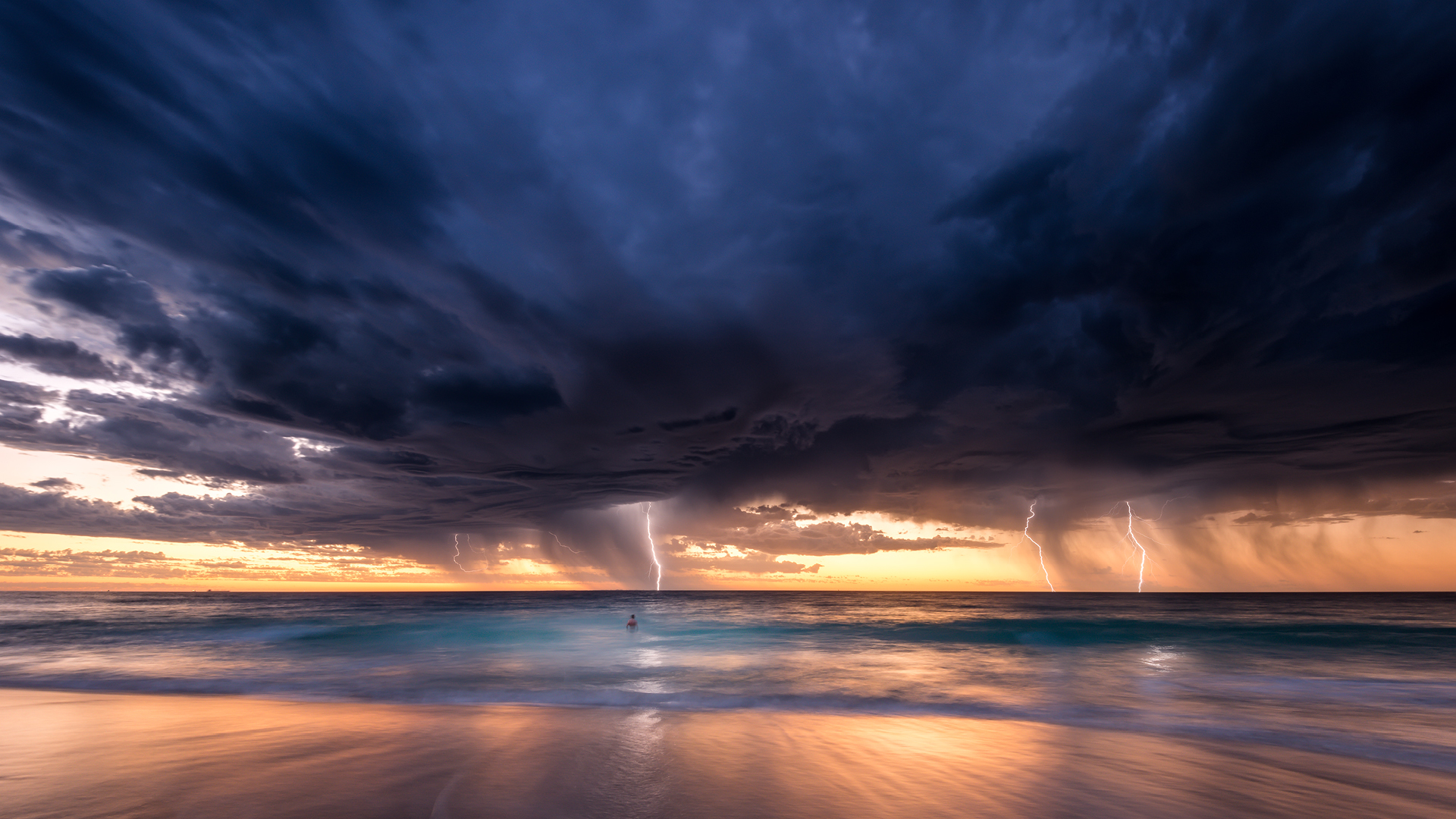
The charge equalisation can happen either between the top and the bottom of clouds (cloud-to-cloud or intra-cloud strike), the bottom of the cloud and the Earth’s surface (cloud-to-ground strike), and occasionally between the positively charged cloud-top and a distant negatively charged area of ground (also cloud-to-ground, but called positive lightning – the amount of charge needed to overcome the air’s resistance is so huge that these bolts are particularly dangerous and can travel many kilometres away from a storm cell).
Thunder is a side effect of the heat of the energy ripping through the air. The air expansion along the bolt’s path is so fast that it breaks the sound barrier: thunder. When the electricity is turned off, the air cools rapidly, causing more reverberations. Bounce that sound around a bit, plus allow for the several strikes that actually make up one complete bolt of lightning, and you end up with a roll of thunder.
There’s also a wide array of lightning we don’t get to see from the ground but which has been observed by pilots and people in orbit. They have some great names – sprites, blue jets and tortured ELVES (Emission of Light and Very Low Frequency perturbations due to Electromagnetic Pulse Sources) among them – but little is known of these phenomena.
Some wish for clouds to go away, many of us wish for more – but either way, it’s hard to deny that these enormous, heavy and complicated structures are fascinating, despite often passing overhead completely unnoticed. And after all of that, we’ve barely scratched the surface, which if you were ever to try to do, would show even more cloud underneath. It’s kind of the nature of the beast.
This article was written by Nate Byrne, meteorologist, oceanographer, ABC presenter and all-round science nerd, for Cosmos Magazine Issue 86.
Cosmos magazine is Australia’s only dedicated print science publication. Subscribe here to get your quarterly fill of the best Science of Everything, from the chemistry of fireworks to cutting-edge Australian innovation.
Login or Sign up for FREE to download the educational resources