The 2019 White Island disaster was a horrific — but growingly rare — tragedy. Professor Jocelyn McPhie explains the volcano monitoring technology making eruptions less frequently fatal.
This resource is best suited to Year 4, 5, 6, and 8 Earth and Space and Chemistry students who are learning about the importance of science and technology in understanding, and protecting people from volcanoes.
Word Count: 1510
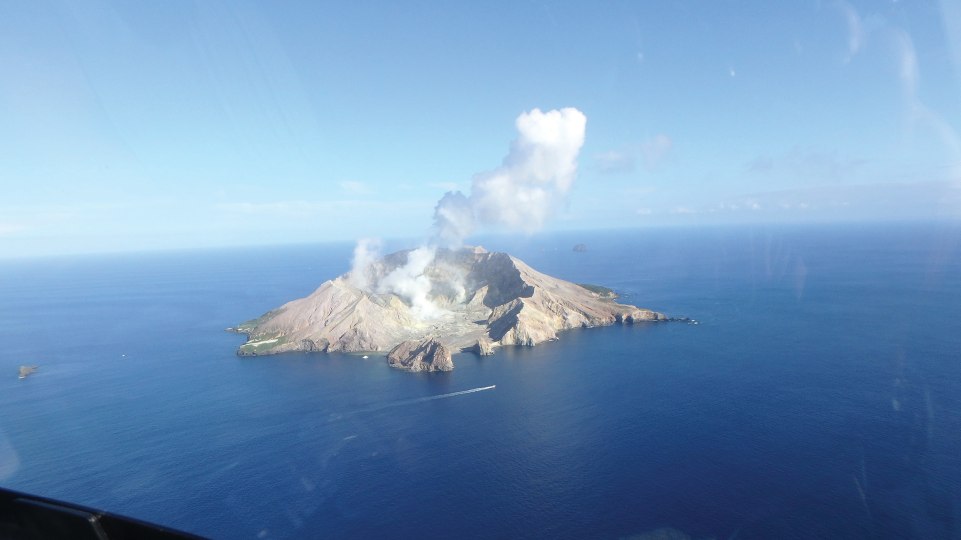
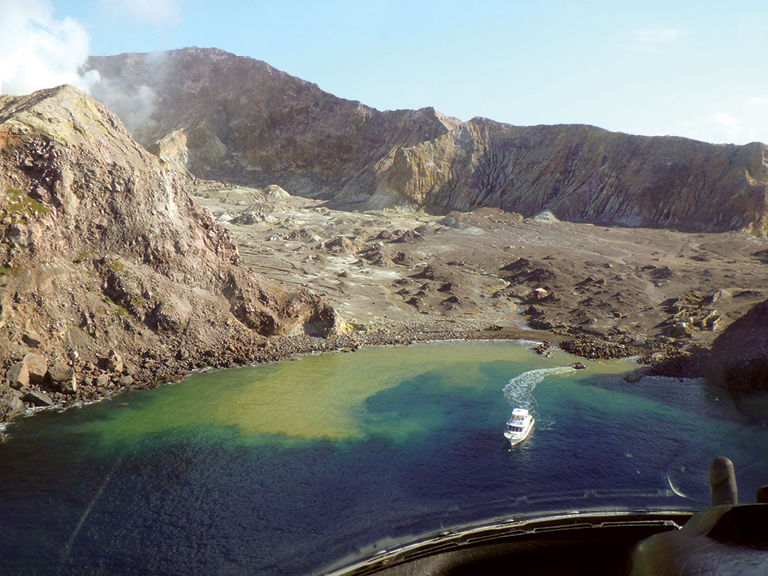
White Island (aka Whakaari) is an active volcano in the Bay of Plenty, 50 km offshore from Whakatane on the coast of the North Island of New Zealand. The volcano came to international attention in December, 2019, following a fatal eruption that resulted in 21 deaths.
This eruption is not the deadliest in New Zealand’s history of volcanic disasters but it is no less tragic. All the victims were tourists or tour operators, expecting to enjoy an adventure on an active volcano. The key word here is “active”, meaning that an eruption could occur without warning, so a visit is inherently risky.
Hazard vs risk
Assessing volcanic risk is an important task of modern volcanology. Volcanologists make a distinction between volcanic hazard (all the destructive eruption-related phenomena that could happen) and volcanic risk (the extent of the loss of life and damage likely to occur as a result). A volcano can be highly hazardous, but if it is very remote, presents low risk, at least to human communities.
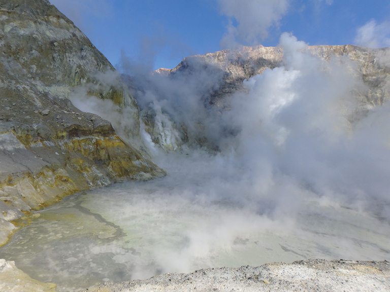
The hazards posed by White Island are high because its typical style of eruption is explosive. Explosive eruptions are driven by expanding gas that breaks apart magma and wall rock around the vent. The mixture of hot particles and hot gas is expelled into the atmosphere with great force in a matter of seconds to minutes.
Also, for most of its history, the vent on White Island has been flooded by a hot acidic lake, so acidic lake water is expelled first when the volcano erupts.
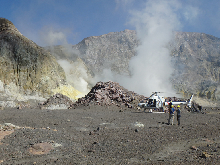
The volcanic risk on White Island is a somewhat unusual case because it is uninhabited and remote: circumstances which would normally render the risk quite low. However, the island is visited almost every day by tourists who get there by helicopter or boat, and while they are on the island, the risk is very high.
The risk is heightened by the fact that all locations on the island are relatively close to the active vent (<1 km). That is because most of the volcano is under water — only the top few hundred metres are exposed above sea level.
Also, the vent is surrounded by an amphitheatre formed by a prehistoric collapse of the southeastern sector of the cone. The open side of the amphitheatre offers a good place for helicopters to land and, at the shore, a good place for tour boats to berth.
When an explosion occurs, the clouds of hot gas and particles go up above the vent but also sideways along the amphitheatre. Any one setting foot on White Island is therefore immediately in the most exposed location on the volcano.
Monitoring magma
Worldwide, there are numerous cases where human communities co-exist with active volcanoes. Very little can be done to reduce the hazards but the risk can be managed and to some extent mitigated. In simplest terms, the approach is to monitor the volcano at rest in order to then detect unrest that could lead to an eruption.
Unrest is a signal to local authorities and communities to prepare for an eruption, possibly including evacuation, and thereby mitigate the effects of the eruption if it happens. The changes that can be detected prior to an eruption reflect the rise of magma to a shallow level in the conduit below the vent. There are four types of change of importance in detecting unrest — earthquakes, gas emissions, temperature and the shape of the volcano.
A great deal of science and technology underpin monitoring. For example, White Island is continuously monitored by GeoNet, the agency responsible for providing geological hazard information for New Zealand.
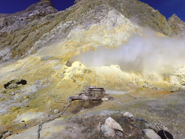
A type of earthquake known as volcanic tremor is associated with the rise of magma that usually precedes an eruption. Because rising magma affects the volume and composition of gases coming from the vent and from fumaroles, especially SO2 content, ultraviolet spectrometers are employed to measure and record SO2 emission rate.
Four cameras are positioned for strategic views (three on the island, one in Whakatane) and take photographs every ten minutes. Two seismometers on the island record earthquakes, the signals from which are automatically analysed to distinguish the location and type of earthquake involved.
Surface and air temperatures increase dramatically in and around vents and fumaroles when magma reaches shallow subsurface levels. Rising magma pushes and squeezes the rocks around the conduit, producing detectable changes in the shape of the volcano (“ground deformation”).
Satellites and sensors
In addition to these instrument-based monitoring techniques, the island is visited regularly by GeoNet geologists for the purpose of collecting gas and water samples, directly measuring fumarole temperatures and recording observations of any changes over time. This array of monitoring techniques is standard at most active volcanoes.
For the past few decades, ground-based monitoring has been augmented by satellite and airborne monitoring techniques, collectively referred to as “remote sensing”. Remote sensing primarily contributes data on gas flux and composition, temperature and ground deformation.
Earthquake data remains tied to ground-based instruments. The remote sensing approach to data collection has the major advantage of being entirely safe and, at least in the case of satellites, the data is being collected and made available continuously in real time.
Satellite-borne instruments that measure both the ultraviolet and infrared regions of the spectrum are used to monitor volcanic sulphur dioxide emissions from large eruptions. At some volcanoes, CO2 emissions are an important prelude to an eruption. Satellite-based remote sensing of CO2 developed in the past decade is capable of detecting volcanic CO2 inputs into the lower atmosphere with high precision.
Anomalies in surface temperature are detected by the Landsat Thematic MapperTM. LandsatTM images are routinely used to detect and monitor temperatures in and around active volcanoes.
With regard to ground deformation, satellite-based measurements of surface displacements have achieved mm-scale accuracy. The most widely used technique is Interferometric synthetic aperture radar (InSAR) which uses differences in the phase of radar waves returning to the satellite to generate maps of surface deformation.
Watching from the sky
Remote-sensing technology has also greatly enhanced our ability to make accurate topographic maps (“digital elevation models”) of volcanoes. This data underpins our prediction of the pathways lava, floods or explosive eruption clouds are likely to follow when eruptions begin.
Aircraft, both planes and helicopters, specifically fitted with monitoring equipment may be employed to survey some volcanoes in cases where the satellite data are inadequate in resolution or of insufficient quality. The kind of data collected is essentially the same as those collected by remote sensing, although some aircraft are also capable of flying through and directly sampling the clouds produced by explosive eruptions.
Drones, also known as unmanned aircraft systems, are increasingly being used to collect data and make observations at active volcanoes. They have the advantage of being relatively inexpensive and highly adaptable to different conditions.
Drones allow volcanologists to “enter” and examine active vents and craters that are otherwise inaccessible and extremely dangerous, being unstable and filled with deadly hot gasses. As well as high-resolution images and real-time videos of what is going on in vents and craters, some are also able to retrieve gas samples.
Discovering the past
Alongside the sophisticated science and technology underpinning volcano monitoring is an equally important effort to understand and model what volcanoes are capable of. Only by knowing how a volcano has behaved in the past can we properly assess the type and severity of hazards that future eruptions pose.
This information is obtained by tracking the volcano’s history, a story that can be read from the volcanic formations exposed in and around the volcano and calibrated by determining the ages of the various formations.
In some cases, historic eruptions provide a sound guide to the ages of various events but in most cases, the volcano’s history is much longer than recorded human history. Determining pre-historic ages involves very precise measurement using a mass spectrometer of radioactive isotopes present in the minerals found in natural volcanic rocks. Knowing established rates of change from one isotope to another, the relative proportions of isotopes give an idea of how old the formation is.
Such a chronology of eruptions commonly reveals average eruption frequencies and in particular, the frequency of the most hazardous eruptions through the life of a volcano. Together with monitoring data, eruption histories are the main tools for predicting how a volcano will erupt in the future. The eruption history of White Island is only imperfectly known because most of the volcano is under the sea and has not been sampled, and the formal record of historic events goes back only about 200 years. The recorded history shows very clearly that eruptions such as that in December, 2019, have been frequent in the past, together with less hazardous eruptions of lavas.
The December 2019 tragedy had a life-changing impact on the survivors, the families of the victims, and the wider community. But from a scientific perspective, the eruption was “normal” for White Island, and similar events will undoubtedly occur again. As our understanding of volcanoes continues to grow, so too will our ability to save more lives.
Written by Professor Jocelyn McPhie FTSE.
Jocelyn McPhie is a world-leading volcanologist and an Adjunct Professor at University of Tasmania. Her research contributes directly to the knowledge and understanding of fundamental physical volcanology, and the links between volcanic and hydrothermal processes. Jocelyn has visited White Island many times, as leader of a Masters Field Course in Volcanology. She also operates as a consultant to the minerals industry, providing technical advice and professional training in volcanology. She was elected a Fellow in 2014.
![]()
This article is reproduced with the kind permission of Professor Jocelyn McPhie FTSE, University of Tasmania.
This article is from the 2020 edition of IMPACT magazine by ATSE. You can access the full magazine collection here.
Years: 4, 5, 6, 8
Login or Sign up for FREE to download a copy of the full teacher resource